Climate

Damage to a forest road caused by a storm in June 2009, photo: Josef Gasch
Climate
Climate
The catchment area, characterized by steep slopes (96 % of the area is steeper than 10 % and 55 % is steeper than 30 %), is part of the Rosaliengebirge, which belongs to the eastern foothills of the Alps on the state border between Lower Austria and Burgenland in Austria.
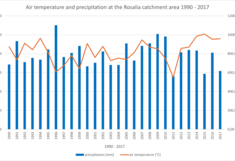
From 1990 to 2017, the annual precipitation was between 560 and 1100 mm (average 795 mm, standard deviation 129 mm), and the average annual air temperature was between 5.5 and 10 °C (average 8.2 °C, standard deviation 1.2 °C).
Data source: DEIMS.org
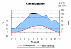
The second figure shows the values for the training forest (Heuberg station) for 1990-1999 averaged as a climate diagram according to Walter and Lieth. The scale for monthly precipitation changes from 100 mm to 1/10 and the corresponding area is filled in black. If the precipitation curve lies above the temperature curve, this is a relative rainy season (humid climate). Relative dry season (arid climate) is present if the temperature curve lies above the precipitation curve. The annual mean temperature and the total precipitation are shown at the top right of the diagram.
The area belongs to climate type VI according to Walter, the temperate humid zone with a pronounced but not very long cold season. The average daily precipitation shows a continuous increase during the course of the day with a strong maximum in the early evening. This is related to the increase in convective activity (thunderstorm activity) in the insolation period and the decrease in the radiation period.
The highest wind speeds on the Heuberg occur in spring and fall. Low wind speeds prevail in February and July until the end of September due to consistent high pressure weather conditions. North, north-west and south winds prevail on the Heuberg with roughly the same frequency. Westerly winds occur less frequently in the area of the Rosaliengebirge due to shielding and deflection at the Alpine arc. Similar conditions exist in the Kuhwald. However, the north-westerly winds are somewhat less frequent on the north-eastern slope. The higher wind speeds in the Kuhwald are mainly due to northerly winds. The south winds, which occur with the same frequency on the Heuberg, lose much of their speed in the Kuhwald lee.


