Assessing land-system change and its impacts on ecosystem patterns and processes
SUPERVISOR: Karlheinz ERB
PROJECT ASSIGNED TO: Sarah MATEJ
The colonization of terrestrial ecosystems by humans plays a major role in global environmental change. While aiming to maximize provisioning ecosystem services for the retrieval of timber, fibres and food, intrinsic trade-offs have led to manifold impacts on the environment, such as negatively affecting biodiversity and the climate system. These unintended consequences of land use are now recognized as a substantial threat to ecosystem resilience and in turn have caused the degradation of the same resource base humans depend on.
Land system science applies a socio-ecological systems perspective by integrating research on land-cover change and land management with underlying socio-economic processes. Understanding the complex and dynamic interactions between socio-economic drivers of land-system change, the consequent alterations of ecosystems and resulting adaptation strategies is crucial to counteracting ongoing sustainability crises and requires comprehensive databases on spatio-temporal patterns of land use, including data on land-use intensity. While timeseries data on land cover has become widely available and used over the last decades, consistent data on land management and land-use intensity is still lacking, but is necessary to fully understand more subtle aspects of land-system change.
This research project aims to analyse changes in global land use and land-use intensity patterns over the last decades at high spatio-temporal resolution in order to answer following research questions:
- Which major trends in land-system change have shaped the recent past and what are the underlying socio-economic and ecological processes?
- How have long-term and short-term dynamics impacted global and local land-use trajectories?
- How can transformation of land systems contribute to future sustainable development?
The basis for land-system change analyses is the collation of a database comprising information on biophysical as well as socio-economic states of societies. This includes data on land-use area, land-use intensity, Carbon flows, NPP, etc. on the one hand and data on population, biomass demand, the livestock system, trade, etc. on the other hand. The integration of these types of data is not without its challenges, due to differences in temporal and spatial resolutions. However, building on existing approaches and advanced remote sensing products, unprecedented spatial and thematical resolution can now be achieved.
This study’s analysis of land-use intensity will take multiple dimensions of input- and output intensity of production systems, as well as the alteration of ecological system properties into account. The framework of human appropriation of net primary production (HANPP) provides such a systems perspective, while also incorporating production systems’ inputs and outputs. HANPP allows for a consistent measure of land-use intensity and the resulting pressure on ecosystems across croplands, grazing lands, forests and built-up lands and has been used to analyse long-term trajectories of land systems, as well as impacts on biodiversity, other ecosystem services and human use of fire.
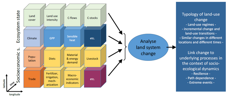
Illustration of the consistent integration of land-system relevant indicators along space and time to allow for analysis of land-system change (from FWF project “LandCube” proposal).
To identify and understand complex spatio-temporal patterns, data-driven exploratory analyses are necessary. Among others, spatio-temporal cluster analysis will be applied to detect common characteristics and trajectories of land systems and their determining drivers. By taking advantage of an unprecedented wealth of Earth Observation data, ever-improving model-derived and statistical data and employing sophisticated data analyses tools, this study aims to generate novel insights into the nature and dynamics of land-system change, thereby contributing to meeting the sustainability challenges of today and tomorrow head on.