
A data-driven landslide hazard characterization and slope stability assessment impacting infrastructure: a case of the Bhutan Himalaya
Supervisor: Christian ZANGERL
Project assigned to: Karma TEMPA
Introduction
Landslide hazard and slope stability management requires a holistic methodology that integrates data-driven hazard assessment and characterization. In Bhutan, frequent landslide-induced disruptions to critical infrastructure, such as roads, retaining structures, bridges, and settlements cause immense damage and loss (Dikshit et al., 2020). This highlights the urgent need for rigorous, data-driven stability assessments, which play a vital role in understanding slope failure mechanisms in the Himalayan region. Given the ongoing evolution of climatic conditions, the adoption of innovative and integrated approaches is essential for monitoring and investigating landslide processes to ensure effective risk management, particularly in mountainous terrains. Without such assessments, sustainable infrastructure development and disaster risk reduction remain impractical.
Despite this pressing need, geoscience knowledge in developing nations like Bhutan remains largely underutilized. The Bhutan Himalaya, particularly the Lesser Himalaya, currently lacks a systemic, process-based knowledge that links geological, geotechnical, and hydromechanical controls on slope instability. Furthermore, while the region exhibits high geological susceptibility (Tempa et al., 2021) and intense responses to rapid climate change, the specific failure mechanisms that govern landslide initiation and progression under these conditions remain complex phenomena, due to which the knowledge of landslide failure mechanisms in the study region remains poorly constrained.
Study area
The study area (Figure 1) falls within the two districts of Chukha and Thimphu, with a particular focus on the Phuentsholing region, and encompasses the Asian Highway (AH-48) corridor that connects the commercial hub of Phuentsholing in Chukha to the capital city, Thimphu.
Aim
This PhD research aims to implement data-driven landslide hazard characterization that connects local and regional-scale analyses through two core components spanning the Lesser Himalaya in the south and the Greater Himalaya Sequence in the north of Bhutan. Both components rely on sufficient field data to enable in depth understanding of landslide failure mechanisms and direct application of slope stability assessment approaches.
- Characterization of highly weathered phyllitic soil and slope failure mechanisms in the Lesser Himalaya of Bhutan. This component focuses on field-based lithological characterization, weathering grades classification, and understanding the role of shear strength reduction in slope failure mechanisms. A case of phyllitic slope failure has been shown in Figure 2.
- Application of characterization-based stability assessment to rock and earth road cut slopes along AH-48 in the Bhutan Himalaya. This component evaluates both failure mechanisms in rock masses and earth slopes. A case of rock mass failure event in AH-48 is shown in Figure 3.
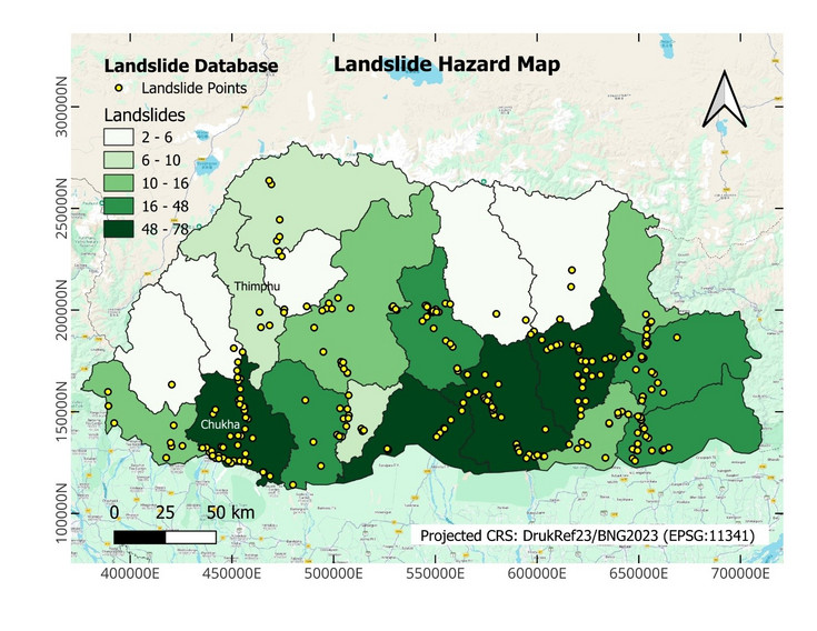
Figure 1. Landslide database for Bhutan (Tempa & Yuden, 2023) showing district-level landslide hazard and spatial distribution of historical landslides. The region of interest (ROI) of the research consists of Chukha and Thimphu districts connected by the Asian Highway AH-48).
Methods
1. Site selection and sampling strategy
For the first component, a study area covering several local administrative boundaries within the Chukha district which falls under the Lesser Himalaya sequence is considered. Phuentsholing being one of the most affected areas by the landslide hazard is focused. A geospatial database will be created to map landslide points within the study area using optical imageries and google earth and the landslide inventory map will be developed. Several landslide locations will be evaluated in the field to determine the weathering grades, and subsequent geological and geotechnical characterization will be conducted. 15 active landslide locations are identified for field assessment and the relevant field data will be populated within the geospatial database using open-source QGIS tools.
For the case studies, the landslide impacting critical infrastructure will be chosen for further risk modeling and analysis. Samples from the case studies corresponding to each of the lithological units will be collected for laboratory tests.
In the second component, the study is targeting around 20 to 30 points along the AH-48 covering up to 110 km till Damchu from Phuentsholing. This stretch experience one of the highest slope failure issues in Bhutan.
2. Earth slope workflow
a) Field work: The methodology employs systematic geological field survey using open-source tools (QGIS tools) for landslide inventory mapping and subsequent weathering grade classification according to relevant standards (e.g., ISRM/BS5930) and in-situ density tests. A case-based UAV-based photogrammetry and satellite imagery will be used for scarp geometry and associated parameters, evaluation of landslide historical events and understanding the slope failure mechanisms through slope modeling and analysis.
b) Laboratory testing: Sieve analysis for soil classification, direct shear or triaxial testing and other relevant geotechnical tests will be conducted. The study also includes mineral profiling (e.g., XRD) for determination of mineral composition of the phyllitic rock/soil samples.
c) Modelling: Especially, in earth slopes, the finite slope failures are prominent at the source area of the main landslides. The research considers evaluation of strength reduction phenomenon on slope failure mechanisms through back analysis using limit equilibrium (e.g., Bishop/Morgenstern-Price: Slide2) and numerical models (e.g., RS2) calibrated against lab-driven strength parameters and regional rainfall records.
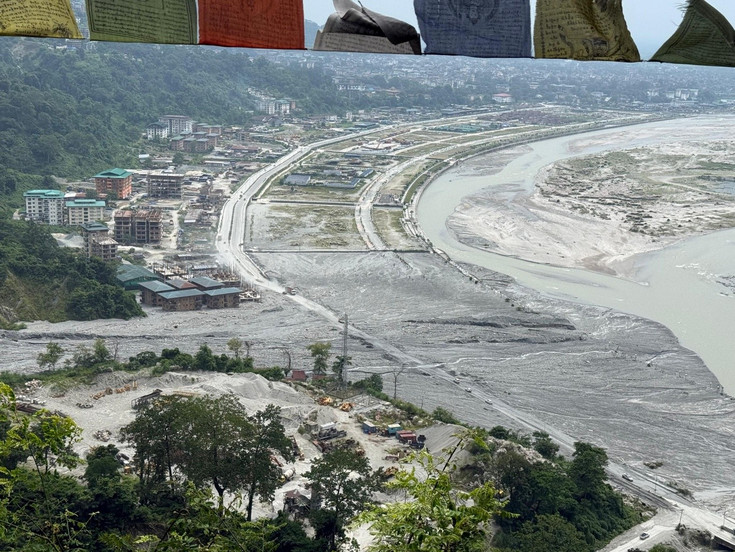
Figure 2. Monsoon-induced earth slope failure in July 2026 and subsequent sediment deposition over the settlement area and road infrastructure.
2. Rock slope workflow
Field work: The workflow for field-based slope mass characterization along the AH-48 corridor includes three approaches based on the type of slopes.
a) Blocky or jointed rock masses: Implement Rock Mass Rating (RMR) (Bieniawski, 1973; Bieniawski, 1989) for Slope Mass Rating (SMR) (Romana, 1985) and field-based data collection such as uniaxial compressive strength test (UCS – Schmidt hammer), and Rock Quality Designation (RQD). The workflow includes geological survey, discontinuity mapping (orientation, spacing, persistence, roughness, infilling), and groundwater conditions. In addition, kinematic analysis using Stereographic/software-based (e.g., Dips) analysis will be conducted to assess potential structural controlled failures for planar, wedge, and toppling modes along the AH-48 (e.g., Figure 3).
b) Weathered rock masses: Geological Strength Index (GSI) (Hoek & Brown, 2019) and the workflow include rock mass characterization (lithology, weathering grade, color, texture, and presence of shear zones or faults, and note any relict structures), structure assessment (blockiness), surface condition assessment, and groundwater conditions. GSI is used as input for Hoek-Brown strength parameters.
c) Earth slopes: For the earth slopes instability along the AH-48, the method provided in earth slope workflow will be implemented.
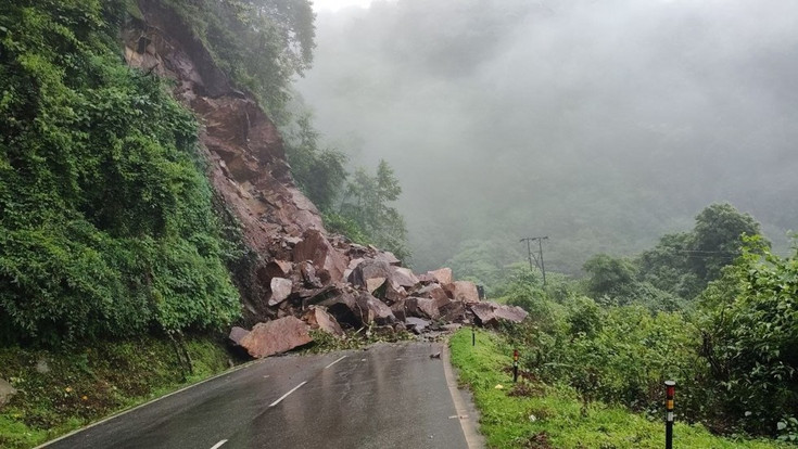
Figure 3. Rock mass failure along AH-48 (Source – Kuensel, July 2026)
Expected outcomes
1. Weathering grade classification, lithological characterization, mineral composition and assessment of the role of shear strength reduction in slope failure mechanisms, for weathered phyllitic slopes.
2. Rock mass characterization and kinematic vulnerability matrices for rock cut-slopes, including:
3. Rock mass quality classification
4. Failure mode susceptibility
5. A georeferenced database (GeoPackage) for the study area, integrating field data and landslide inventory.
6. In particular, the research identifies slope failure mechanisms and potential slope failure risk to enhance landslide disaster risk reduction in Bhutan Himalaya through data-driven approaches.
Conclusion
This field-data-driven approach will enhance landslide resilience and disaster risk reduction (DRR) initiatives. The resulting slope stability assessments are designed to provide long-term support for landslide risk management strategies for sustainable infrastructure and mitigation solutions in Bhutan and similar mountainous regions.
Acknowledgements
This research work is one of the core components of the KoEF204 INSPIRE project within the consortium of BOKU University (Austria), the University of Innsbruck (Austria), Tribhuvan University (Nepal), and the College of Science and Technology, Royal University of Bhutan (Bhutan). The consortium thanks Prof. Christian Zangerl for leading the project and the OeAD for the funding support.
References
Bieniawski, Z. T. (1973). Engineering classification of jointed rock masses. Transaction of the South African Institution of Civil Engineers, 15, 335–344.
Bieniawski, Z. T. (1989). Engineering rock mass classification: A complete manual for engineers and geologists in mining, civil, and petroleum engineering. Wiley-Interscience.
Dikshit, A., Sarkar, R., Pradhan, B., Acharya, S., & Alamri, A. M. (2020). Landslide risk assessment using hazard and vulnerability mapping in the Bhutan Himalayas. Geosciences, 10(4), 131. https://doi.org/10.3390/geosciences10040131
Hoek, E., & Brown, E. T. (2019). The Hoek-Brown failure criterion and GSI – 2018 edition. Journal of Rock Mechanics and Geotechnical Engineering, 11(3), 445–463.
Romana, M. (1985). New adjustment ratings for application of Bieniawski classification to slopes. In International Symposium on the Role of Rock Mechanics in Excavations for Mining and Civil Works (pp. 49–53). International Society of Rock Mechanics, Zacatecas.
Tempa, K., & Yuden, K. (2023). Multi-hazard zoning for national scale population risk mapping: A pilot study in Bhutan Himalaya. Geoenvironmental Disasters, 10(1), 7. https://doi.org/10.1186/s40677-023-00239-4
Tempa, K., Peljor, K., Wangdi, S., Ghally, R., Jamtsho, K., Ghally, S., & Pradhan, P. (2021). UAV technique to localize landslide susceptibility and mitigation proposal: A case of Rinchending Goenpa landslide in Bhutan. Natural Hazards Research, 1(4), 171–186. https://doi.org/10.1016/j.nhres.2021.10.003