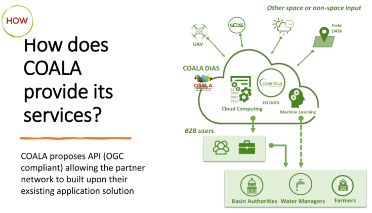
The curation of a COALA data centre is essential as access to information in real-time (or as close to as possible) is very high on the wish list of farmers and agricultural practitioners. Agriculturalists are looking for more efficient and effective ways to manage nutrients and water in their paddocks. In the first year of the COALA project, we performed a co-creation process to understand user requirements better. And their needs were loud and clear . Our stakeholders identified critical information that guides our Earth Observation data and processes in support of COALA. 

Potential users of our products and services told us that our applications must be easy to use, and mobile compatible and must integrate outside data. We realised that we had to make COALA data easily accessible and not complicated.


The University of Life and Natural Sciences of Vienna (BOKU) is a partner of COALA. Our expertise is in applied EO and geospatial technologies related to agriculture and landscape planning. We have experience developing operative solutions for large-scale satellite data processing for various agricultural applications, including transfer of technology for irrigation, drought and yield monitoring.  In the COALA consortium, we are leading the work on process flows and system operation; we are responsible for developing the COALA processing environment using the DIAS concept (which stands for Copernicus Data and Information Access Services). These services will provide easy access to Copernicus data and information for Australian users. Agricultural technology is dynamic, and we are too. We adapt new Earth Observation services and helping integrate them for seamless user interfacing. We want to create streamlined, helpful services by combining earth observation technologies and cloud computing.


Where is the COALA platform?

COALA plans to develop and provide data-as-a-service (DaaS), allowing an automatic bi-directional server-to-client protocol communication. The “server” is the COALA infrastructure that comprises mostly Copernicus Sentinel-2 products. The server’s job is to process workflows and a suite of COALA products to support irrigation and nitrogen management decisions. Due to the large amount of data that the satellite Sentinel-2 collects (one image every five days over the same point in Earth), we had to use algorithms for fast processing of data and its conversion to ‘bits of information’ that are meaningful and of use in agriculture.

We also want a cost-effective, flexible and scalable processing system.  Therefore, we are implementing the COALA server using cloud computing infrastructure to offer Copernicus data and processing capacities ‘in one place’. A necessary and important component of the project is to ‘scale’ from individual and sparse paddocks to district scale, covering different geographic regions (this is similar to zooming out, we look at a paddock in detail, but we also need to be aware of the surrounding landscape, and for that, we aggregate data from paddocks to sub-catchments, to catchments and to larger landscape units). 

We host our COALA server on the Earth Observation Data Centre for water resource management (EODC) in Vienna. At this data centre, BOKU already implemented the first processing platform for atmospherically corrected Sentinel-2 data in 2016. The EODC is a private-public partnership, and together with internal and external experts; EODC helps scientists and businesses to close the gap between research and practice to foster the operational use of a large amount of satellite data, with a focus on environmental and climate monitoring, agricultural applications, infrastructure management, and humanitarian aid and civil security. To learn more about EODC, visit https://eodc.eu/

On EODC, BOKU deploys the pre-operational version of the COALA platform. The access points are based on scripts, data and process workflows that have been defined and coded. In practice, the access points use a RESTful Application Programming Interface (API) standard to trigger data processing, exchange information with the users, and obtain final products. We will soon make some access points available to the broader public. Here you can access products for irrigation and nutrition management to be integrated into your precision farming business.

During the COALA project, we expect to provide a flexible and diverse processing environment. We want our data to be useful and easily accessed for the varied needs of Australian farmers. Stay tuned and follow us!


The COALA API story

Contact person

Francesco Vuolo, Dr.

Deputy
H85700 Institute of Geomatics

Email
francesco.vuolo@boku.ac.at
Phone
+43 1 47654-85735
Postal address
Institute of Geomatics
Peter-Jordan-Straße 82
1190 Vienna