Mountain communities like in Tajikistan are at risk to a variety of geohazard processes. These processes may be classified in different ways. One approach would be to distinguish between local geohazards and remote geohazards:
- Local geohazards have their source area close to the area of impact. The events are usually of low to medium magnitude and medium to high frequency. The communities at risk are therefore exposed to the processes relatively often, and are located close to the source area. They usually know how to cope with the hazard and the risk, and this knowledge is transported from one generation to the next. Typical local geohazards are small to mediium-size debris flows, small landslides, or floods.
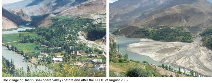
- Remote geohazards have their area of impact far up in the mountains. They occur at long intervals, and the magnitude is often high. Due to the low recurrence rate and the long distance, mountain communities are often not aware that they are at risk. Therefore, they are specifically vulnerable and hardly prepared to such events. If an event happens, it usually claims a large number of lifes. Remote geohazards include large landslides or glacial lake outburst floods (GLOFs), often involving cascading effects.